Travel time models
Usually 1D travel time models are used for seismic events location in large rather uniform regions. 1D means that for such models travel time of a seismic wave between two points depends only on a distance between the points:
T(j1, l1, j2, l2) = T(R(j1, l1, j2, l2)), where R is distance between two points.
Usually such models are stored in a form of wave travel time tables which are computed according with some horizontally layered models of wave conducting medium. Thus, the basic 1D model for the whole Earth is IASPEI91 which is in use in IDC.
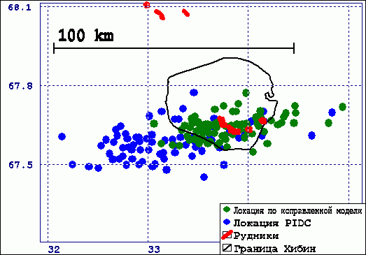
The figure shows location of mining explosions in Khibiny Massif by PIDC network (which includes Scandinavian seismic arrays) in 1995-1997. Mines are shown by red color, results of PIDC locations using IASPEI91 model are marked by blue circles. One can note a systematic error of the locations which is more than 50 km.
The systematic error is caused by significant deviations of local velocities of seismic waves from global IASPEI91 model. Correction of the model enabled to eliminate systematic error. (Green circles are locations of the same events by the same times of waves arrivals but using BARENTS travel time model).
To find a model which is more suitable for our region we selected a set of test seismic events (see figure and table below).
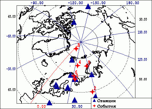
We used data by all seismic stations available include our stations, Scandinavian arrays and IRIS stations (see figure).
| Number | Date | Origin time | Latitude | Longitude | Remark |
| 1 | 29.09.1996 | 6.05:46.19 | 67.677 N | 33.733 E | Calibration explosion in Khibiny Massif |
| 2 | 5.01.1995 | 12.46:01.65 | 59.561 N | 56.566 E | Solikamsk mining earthquake |
| 3 | 26.04.1995 | 8.55:59.33 | 85.088 N | 8.332 E | To north-west from Spitsbergen |
| 4 | 11.06.1995 | 19.27:13.34 | 75.74 N | 34.79 E | Barents sea |
| 5 | 13.06.1995 | 19.22:38.36 | 75.177 N | 56.528 E | Near Novaya Zemlya |
| 6 | 7.06.1995 | 11.09:41.57 | 69.485 N | 30.992 E | Zapolyarny explosion |
We check several travel time models. The events were re-located with their usage. We estimated accuracy of locations and their self-agreement (discrepancy of origin time estimation). For the 29.09.1996 calibration explosion, when exact origin time is known, we computed deviation of observed travel times from modelling ones.
As a result we found that the model used in NORSAR (see table below) is the best one for location of seismic events in our region at distances up to 1500 km.
To locate events at greater distances we add NORSAR model by IASPEI91 for depths greater than 55 km. The resulting BARENTS model is in use in KB GS RAS. It also was accepted by Consortium 2 of CTBTO as a basic model for Barents region.
| Depth of layers top | Vp | Vs |
| 0 | 6.2 | 3.58 |
| 16 | 6.7 | 3.87 |
| 40 | 8.1 | 4.6 |
| 55 | 8.23 | 4.68 |
To improve BARENTS travel time model we had installed seismic stations in Khibiny Massif GFR and RASV (see Seismic network), and temporary stations in Monchegorsk and Zapolyarny. We estimated velocities by Khibiny explosions and by calibration explosion 10.09.2002 in Lovozero Massif and compared them with modelling velocities.
It appeared that P and S velocities in Khibiny and Lovozero Massifs vary significantly depending on source-station path and can differ from BARENTS model values up to 0.15 km/sec. The Massifs are of complicated non-uniform structure.
For longer source-station paths (from Khibiny explosions to Monchegorsk, Zapolyarny and far to ARCES) measured velocities appeared to be very close to modelling ones.
Wave-propagating medium of Spitsbergen and adjacent areas is very complicated and it is difficult or impossible to use a single 1D model. Thus it is obvious that the velocity section in spreading zone to the west from Spitsbergen is quite different from one in the island part.
We tried to fit 1D model for location of seismic events near Barentsburg mines using data of nearest seismic stations KBS, SPI and BRBB (see Seismic network).
BRBB station had registered a lot of rockbursts and explosions in the mines at distances 2-5 km apart from the station. By the events we estimated P and S velocities and obtained the values of 4.54 and 2.52 km/sec, typical values for sediments.
We used calibration event 28.01.2001 with known coordinates (78.066 N, 14.324 E) to prolongate the model for far distances. The event was well-recorded by SPI and KBS stations (see figure below).
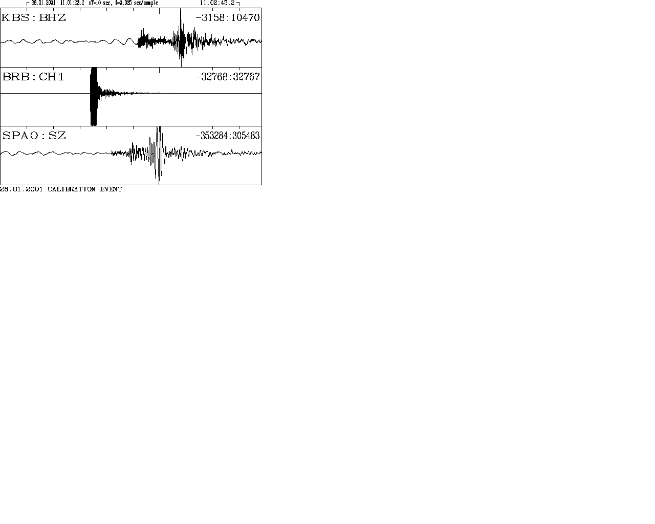
Recordings of the calibration event by BRBB, SPI and KBS.
We tried to modify BARENTS model by adding a layer of sediments. We made a fitting by thickness of the layer and by Moho depth. As a preliminary result SPITS0 model was obtained.
| Depth (km) | Vp (km/sec) | Vs (km/sec) |
| 0 | 4.54 | 2.52 |
| 2 | 6.2 | 3.44 |
| 10 | 6.7 | 3.72 |
| 30 | 8.1 | 4.50 |
| 55 | 8.23 | 4.57 |
We re-located the calibration event using the same stations and models BARENTS and SPIST0. The results are shown in the table below.
| Model | Latitude | Longitude | Error (km) |
| True coordinates | 78.066 | 14.324 | |
| SPITS0 | 78.072 | 14.317 | 0.7 |
| BARENTS | 77.93 | 14.045 | 16 |
The model is currently in use for Spitsbergen events location. For events near Barentsburg it gives a good accuracy. But it is still impossible to check the model for other areas of the Archipelago.